
Meeting up with Cas’ friend Denise was awesome. She was incredibly easy to talk to, so things went smoothly. We went and got wings (my favorite) and then we scouted out a flight park she’s been wanting to find for a while. It’s basically an open grassy at altitude area where hang gliders take off from. Denise asked one guy who had just landed about how he got into the sport. Apparently, it’s pretty easy, sign up for lessons and buy some gear. Then jump off a damn cliff! In that order of course. We watched the jumpers for a bit, then drove down the hill back to her house. I took an amazing shower, then passed out in a super comfy bed.

I slept in after Denise left for work the next morning, cleaned out some water bottles, then went to pick up my friend Kristi from the Salt Lake airport. Kristi and I became friends when I first moved up to Panama City. When I was working for the Florida Park Service, I was tasked with overseeing the imperiled beach mouse subspecies that were residing at our parks. This included three federally endangered subspecies, the Perdido Key beach mouse, Choctawhatchee beach mouse, and the St. Andrews beach mouse. Coming from southwest Florida in my previous role, I had no idea what beach mice were or what they needed as far as protection goes. So I set up a meeting with the US Fish and Wildlife Service beach mouse recovery lead to ask some questions and learn me some stuff. Thus Kristi enters my life. She was bringing a captive bred beach mouse to my office to look after for a few hours, and I of course lost my shit. An adorable little whitish brown mouse? And it’s an endangered species?! I love it!! It’s name was Sierra and was old as shit, looking like she was knocking on death’s door. Sierra was formerly part of a captive breeding program at Brevard Zoo. They are kept as a kind of insurance policy just in case another huge storm wipes out Perdido Key, or feral cats become rampant, or some crazy disease takes hold of the island. You get the picture I hope. Anyway, from that moment on Kristi was a huge ally in the conservation world. And even became a friend.

Fast forward three years from that moment and I’m now living at Kristi’s house in a mother-in-law suite. When this trip started forming in my thoughts, Kristi claimed Utah. Visiting me on my travels was going to be way cheaper than flying out, renting a car, and seeing all these places individually. Hopefully that’s enough backstory…

I pick up Kristi from the airport, and we head out to buy groceries, get my oil changed, and pick up some maps. Being only my second day in Utah, I have not fully figured out the rules here in regards to liquor or alcohol sales. I know they are screwy, but I don’t know just how screwy they are. At the grocery store we look to buy some beer for me and cider for Kristi. Maybe even some hard liquor perhaps? When we get in we see no cider. Does Utah not do cider??? And all of the beer is 4% alcohol by volume. What does that even mean?? I decide to skip the booze and just go for food. We’ll find something else more legit hopefully. With groceries bought and oil changed, we hop into a Seagull’s Book Store which happens to be in the same plaza. Maybe they sell maps? Or a map book? We pop in, and, oh boy. Nope. Just huge amounts of Latter Day Saints (LDS) paraphernalia, huge paintings of Jesus and Joseph Smith, and LDS clothing. In fact, there are literally only a few books being sold here. The book of Mormon, and some supporting book of Mormon text. As soon as I walk in I turn around to leave, but Kristi decides to ask the clerk about map books. Of course they don’t sell them here…. Let’s get out of here! We leave and head over to Barnes and Nobles which of course has exactly what we need.

We decide to head to Capitol Reef National Park that night. There is a free campsite in the Cathedral Valley area of the park, and it’s at some altitude so it should be cooler than the steamy 101 degrees that Salt Lake is currently sporting. We drive three hours south until we get to Dixie National Forest. This is where our pavement ends, and the adventure begins!

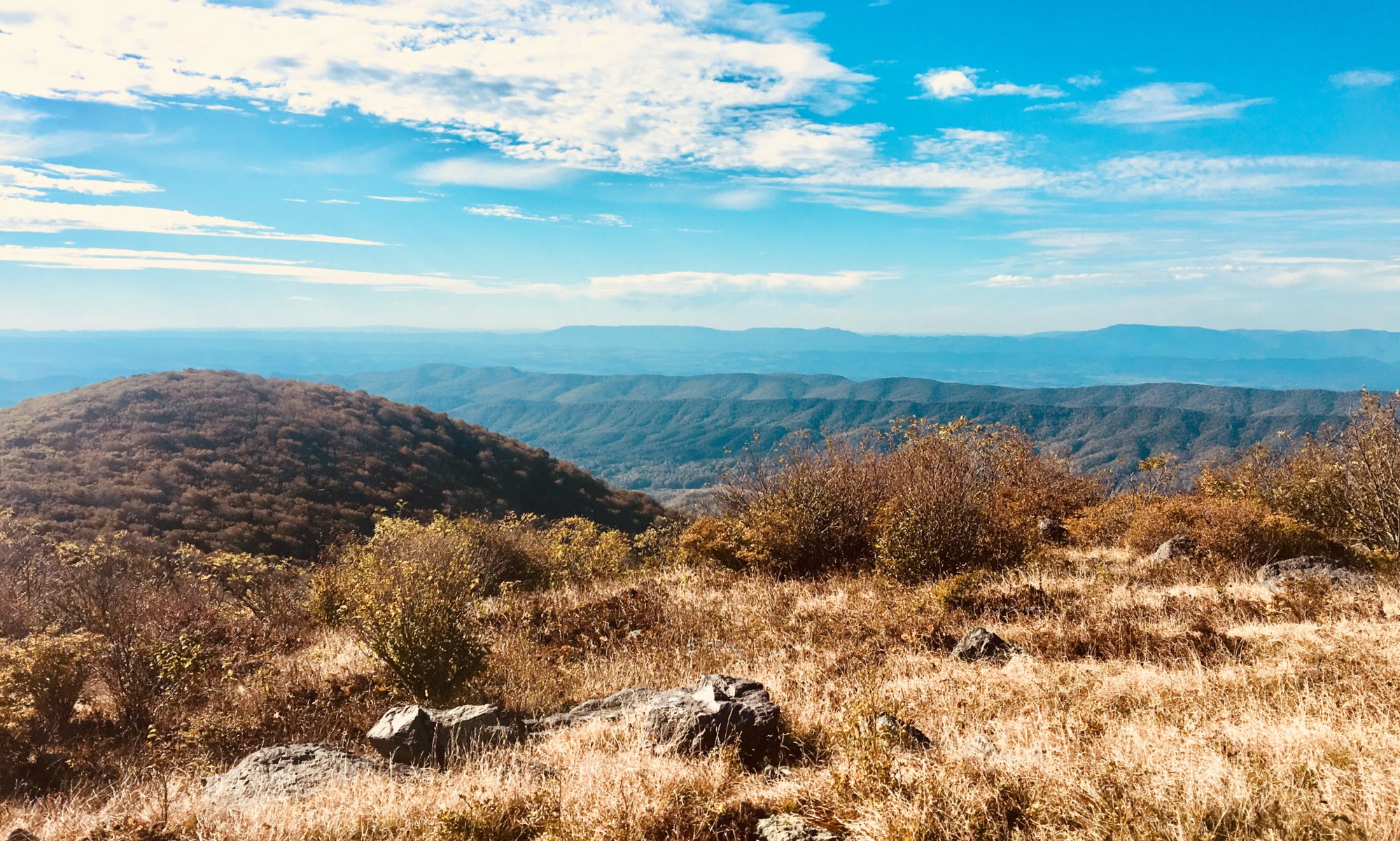
About 40 minutes on back roads brings us to our camping destination. A sweet free park service camping area with an amazing view of curtain-like rock structures. This definitely feels like Utah. We pick a spot, gather firewood, then set out to explore our surroundings. They are vast and beautiful, with perfect lighting. We start a fire at camp and pour ourselves a vodka cranberry. This feels like some serious vacation!


When we woke up in the morning, we decided to drive into the park, visit the visitor center, and get some hiking in. Everything started out great until I left to drive into the park. I took a wrong turn, leading us onto a road that would eventually get us to where we wanted to go, but in about double the time it should have taken us. But we didn’t know. As we climbed down off the plateau we camped at and into the valley, we were awestruck by the rock structures. We didn’t know we were on the wrong road until we hit a named landmark, the Gypsum Sinkhole. I hadn’t planned to stop here, but I’m glad we did. This was a huge ass terrifying hole in the rock. After some pictures and reorienting ourselves, we drove south (along the wrong road) for another hour and a half. Yeah. That’s a long time on shitty washboard dirt road. While driving we pass three kids in a Chevy Impala. I’m not in 4×4, but there are a lot of high clearance issues on this road. We are impressed they have made it as far as they have.


Once on actual pavement, we head towards the park to see what Capitol Reef has to offer. We were both super stoked to see park service orchards! You pick! You can eat as much as you want for free in the orchard, and taking it out is 1$ a pound! We gorged on fresh peaches and apricots until we couldn’t eat anymore, and then we picked a few pounds for the road. Best deal everrrrr!!! Why didn’t anyone tell me there were sweet orchards at this park? Apparently, the Native Americans that lived in this area planted the trees originally, and then the Mormons “took over.” I say that with quotes because there is a long history of Mormons being complete shit bags to the Native Americans. Slaughtering their people and stealing cattle. So, it’s no surprise to me that they took this land over for their own use. Assholes.


After doting on fresh produce for a while, we get to the visitor center to figure out where to go for hikes. It’s starting to thunderstorm out, which isn’t good for desert activities. We hop in, get some maps, and are told that we should not attempt any slot canyon hikes when there is rain potential. Flash floods are a real thing that could kill us. But, if the weather clears up, here’s where you go for sweet slot canyons. We thank the student worker for the maps, fill up our water bottles, and head on our way. We decide to get gas and beer/cider before going into the backcountry and find a gas station just outside the park. Again, 4% beer and no cider. This place is so odd. We fuel up and head back towards the park.

Coming in, we find a Mormon run bakery inside the park. Of course we have to stop, and Kristi buys a tiny peach pie. We devour the pie (made from local peaches) and try to hike off some calories. As soon as we start, lightning hits nearby, scaring us down off the mountain we were attempting to climb. It’s like nature doesn’t want us to exercise… We get back into the car and drive to another trail head to wait out the storm. The second trail we attempted was a land bridge called “natural bridge.” I do not understand why people get so damn excited about land bridges and arches… I mean they are cool, but not that cool… Regardless, we hike to the bridge, take some obligatory photos, then walk back. It’s finally time to get off the beaten path and find a campsite. We drive south, into neighboring BLM property and stop at a trail head named Sheets Gulch. Now, I heard Sheep’s Gulch. Kristi thought it was named after a dude named Steve Sheets. So we called it Steven Sheets Sheep Gulch. Just to cover all our bases.

We walk in the gulch and into some pretty cool narrows until the weather started threatening again. We turned around, not wanting to die by flash flood. On the way back, I almost stepped on the biggest damn scorpion I’ve ever seen….


More driving brought us to Cedar Campground, another free NPS spot that was totally empty. We found a spot, collected firewood, and proceeded to have a great fire and cocktail hour. The next morning, we had plans to do a longer hike known as the upper Muley Twist. This would be a 10-ish mile hike that was only accessible by driving down a 3-mile 4×4 trail. It sounded empty and difficult…. I’m in! We wake up early, eat our oatmeal, and head south.
The trip started with an intense switch back dirt road to get on top of the mesa. This was a little scary but beautiful. Kristi was hanging out of the window taking pics as I was white knuckling the drive. That interaction right there sums up our friendship. Me trying to get us somewhere alive, while Kristi has zero fear, trying to document me freaking out. Once up the mesa, we embarked on our 4×4 trail that was really a dried-up wash. Huge boulders littered the trail, but we managed just fine. Once at the parking area, we did a short hike to get to an overlook (Strike Valley Overlook). Totally worth it. Got some sweet Lion King photos.


Back at the car, we prepped for our longer hike into Muley Twist canyon. It’s called that because early travelers with mules on this path would watch as the animals had to twist their bodies to get through. Allegedly. We packed lots of water, snacks, the GPS and the written description of the trail before taking off. The weather was clear and hot. This seemed like a perfect day for this hike, and we were ready for it.

The first few miles were easy. Follow the wash and look for tons of arches. Our main goal was to find slot canyons, which this trail promised. The written directions said, “slot canyon bypass” which we took as “take this random super steep trail to the slot canyon.” Alas, we were wrong. Staying along the easy path inside the wash would have led us to the canyon. The trail we took was to “bypass” the cool stuff. Who does that?? Once we figured out our error, we backtracked and entered the narrows. They were cool but super short lived. Oh well, guess we should head back it’s getting late anyway… As soon as that thought crossed my mind, it started to rain. Shit. We couldn’t see any clouds while in the narrow canyon. As we got out of the canyon, it started to pour. Double shit. We decide to scurry back, but we have 5 miles…

Within about 2 minutes of the rain starting, the once dry wash had about 6-12 inches of rushing water. Surrounded by tall, slick rock, we had no option but to tromp back through the flood waters to where we were parked. We’d go to high ground and wait it out, but the lighting was close and constant. Triple shit. Being the tallest out of us, I walked first in the tomato red flood waters. The idea was that I would find the deep holes so Kristi could avoid them. Something chest high on me could mean serious trouble for Kristi’s short ass. So, we trudged on. Lightning everywhere, falling in deep holes, and so much sand in your shoes that it was painful. We thought the rain would let up at some point, but we were wrong. It was constant.


It took us an hour and a half to make it back to the car. We had both taken spills that sent us swimming and we were soaked in the red mud head to toe. With our road out completely flooded, we realized we were stranded. Good thing we were prepared to stay the night, or we’d be screwed! We hung up all our wet clothes, toweled off, and made the most of our new island campsite. Hopefully the water will recede by tomorrow morning….


