Mt. St. Helens and the Olympic Peninsula

She was shy

Well, I finally left the big city and headed back into the woods. Cas has bought me a flight to Pensacola starting the 21st, so I’ve got a long weekend to see the Olympic Peninsula before I head east. I decide to hit up Mt. St. Helens on my journey north, and I’m super glad I did. My initial research on the forestry website showed that the major roads to the volcano’s observatories were still closed. Fine. I’ll just see how far I can get and try to find any hikes that are available. Once I got to the first visitor center, I realize all the subsequent roads had been cleared, and the main observatory (Johnston Ridge) was accessible. Way to go Forestry website. You had one fucking job… I grab a map, ask about some good hikes, and head east towards the volcano.

I love the volcano symbol, looks like a mountain fart.

So this thing is impressive. Some of y’all probably remember when St. Helens erupted in 1980. It was a huge deal. The photography of the day before the eruption vs. the day after is striking. Get this, the locals in the area noticed the mountain start to bulge a few weeks before the eruption. Can you imagine the hill billy convo that went on in some of those houses? “Betty-Sue, I swear to GAAAWWWDDD that thing is growing!!” Of course USGS had been monitoring it, and knew shit was about to go down. But still. Would have been scary as all get out to be around that thing. Huge chunks of the mountain were sloughed off into hummocks, spread more than 12 miles away.

Money shot

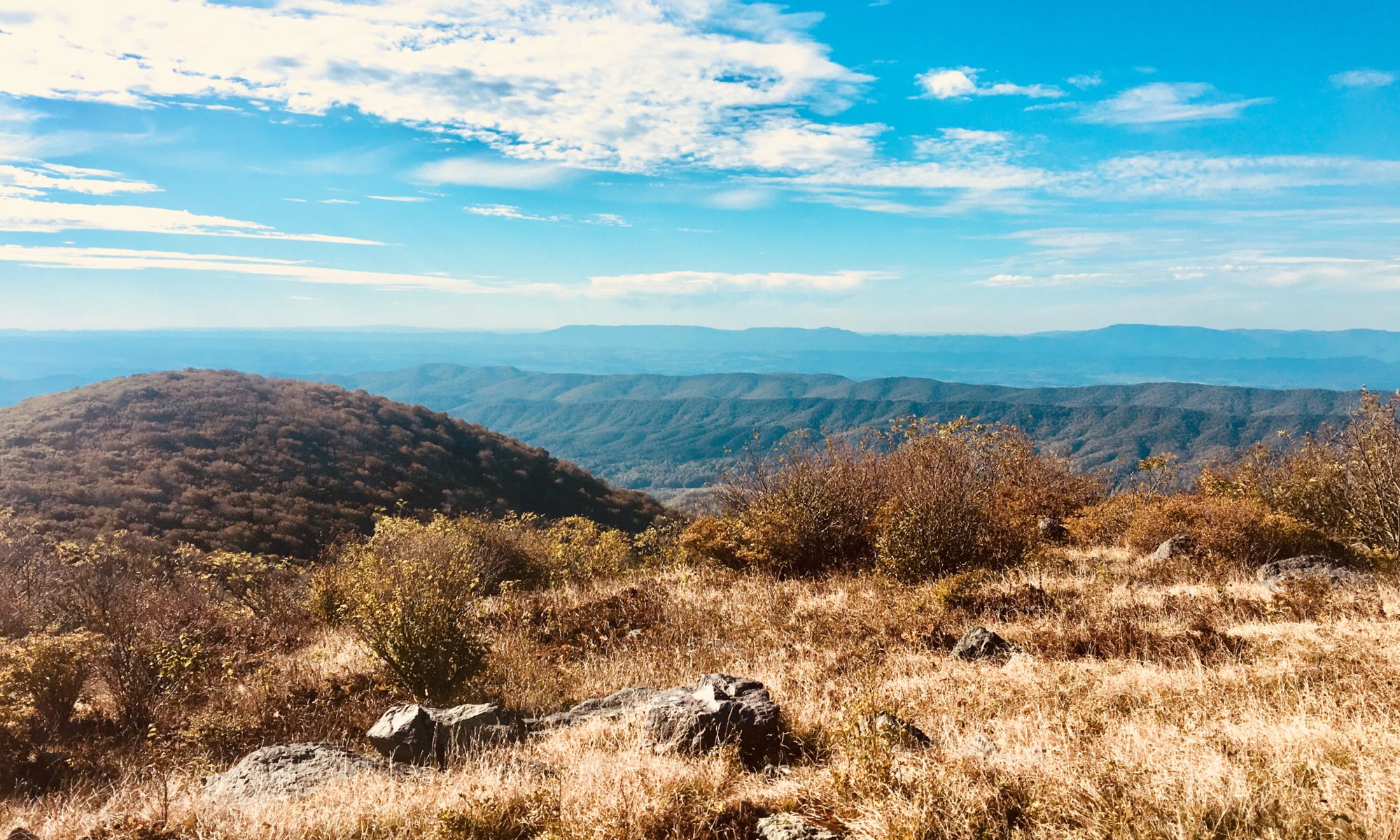
Needing to get my steps in (I’m sure I gained 10 pounds in Portland), I decide to hike a trail near the volcano. Wait. Should I be calling this thing a mountain or a volcano? Are they interchangeable? Does it matter? Anyway, I find a hike and decide to do about 8 miles. It starts out facing the mountain/volcano hybrid, so I have great views. About 2 hours in, I decide to look behind me (I know, great situational awareness right?) and see a storm flying in towards my direction. Well shit. I’m high up on an exposed ridge with no cover for miles. I turn around, throw on my rain jacket, and book it back to the truck.

Exposed trail

Ok. Don’t judge me, but it was just fog rolling in. I couldn’t tell. I swear it looked like a storm dropping sheets of rain, but apparently I just haven’t learned to decipher Pacific Northwest weather yet. So I feel dumb, but I’m too far back to the truck to continue on my hike. I decide to drive up to where the road ends at the last visitor center over looking the ex-mountain. This observatory was underwhelming due to the fog storm that had just rolled in. If there were clear views it would have been astonishing.

This was the best part of the observatory. I did not find any toads 🙁

So, I head back to the truck, and set my sights for a camp spot within the Olympic National Forest. After a two hour drive, I’m on a gravel logging road ascending through dog hair thick spruce and fir, swimming in pea soup fog. It’s an awesome area, lush with a million shades of green. I find a pull out and get set up for the night.

It’s raining all night. Obviously I expected this being in the rainy NW. I did everything in my power to ensure my little camper was water tight before leaving Florida, but alas there is either a new opening, or the amount of continuous rain has forced water through cracks that Florida weather did not find. I wake up to a sopping wet pillow and drenched feet. How lovely!! All I can think about is my co-worker Mike telling me how those campers are just not designed to be water tight. I was trying to prove him wrong of course. But he was usually right about these types of things.

I try to dry things out, sprawling sheets and pillow cases and blankets inside the truck cab. I assess the situation, and come up with a plan of attack. I’ll make gorilla tape shingles to direct water away from what I can tell is the entry point. I think it’s the entry point. I really have no clue. I’ll just fill every crack I can find. That’s what she said….

After my redneck home repairs, I head out to the Quinault rain forest within Olympic National Park to get a hike in, and to see the world’s largest Sitka Spruce tree. While I’m prepping for my first rain forest hike, I look at Instagram and see that my RV compadres I met at Lassen NP are also at Olympic NP. Well shit! Where y’all at?? I send them a quick message, and we plan a rendezvous at a campground just 10 miles from where I had initially planned to stay the night. What are the odds…. Carole has promised chili and French martinis, so of course I am completely stoked. They even snag me a beautiful campsite near them. Talk about a morale booster after my soggy night.

Rain Forest
Spruce

The rain forest is beautiful. Now I know what you’re thinking, because I was thinking it too. Ok really? Rain forest? I know that term just means it gets over 100″ of rain annually, but its got to be too damn cold to be real rain forest-ish. Of course I was wrong. This is a temperate rain forest, but holy hell it is a damn jungle. So lush, moss covering everything, hundreds of herbaceous species competing for light, and massive old trees throwing elbows up at the canopy for sun access. It’s a god damn rain forest.

Ignore my camera strap.

After a quick hike, I stop to see the massive spruce tree, and pick up some firewood for the night. I want to visit the Hoh rain forest next (I pronounce it hoe because it’s hilarious and I don’t know how else to say it), so I drive west and north. The main road, 101, skirts the beaches on the western side of the peninsula. I wasn’t planning on spending any time at the beach, but it’s so close and convenient that I decide to stop a couple times and see what the fuss is about. Well, it’s definitely where water meets the land. The only big difference I can tell is that there is evidence of massive water and wind forces everywhere. Huge logs are thrown everywhere, and massive boulders are strewn about. The amount of energy to move these large objects makes me wonder what this place would look like at a king high tide. Probably fucking insane.

Logggggsss at Ruby Beach

After a few beach stops, I head deep into the Hoh. There’s a hike that parallels the Hoh river leading to the base of Mt. Olympus. This is the hike you would take if you wanted to summit the mountain. I like the idea of this, and decide to do 10-ish miles. The visitor center here is surprisingly lame. I guess the forest is enough of an attraction.

Ze jungle

The first thing I notice is the amount of people on this trail. It reminds me of other large national parks, with tour buses dropping off lots of under prepared hikers in cut-off t-shirts and thin, flat tennis shoes. Once you pass all those assholes, you are totally consumed by the rain forest. Even though it’s relatively cool out, the vegetation holds in heat and moisture, giving you the full jungle effect. Waterfalls dot the hike, along with spectacular views of the river.

Hoh river

At one point, near my 5 mile turn around spot, I see a couple in front of me, maybe 100 yards away. They are stopped, and keep looking back towards me. I wonder what these assholes are doing… Why do they keep looking back at me? Finally I realize the guy is gesturing wildly, pointing to my right. Once I notice what he’s doing, I freeze. He’s telling me something is on my right, but wtf is it? Once stopped, I see a huge brown object just 20 feet off the path in the thick brush. It’s a god damn bear and I’m about to die… My heart is about to jump out of my throat. I stay still, not wanting to startle a creature so close me me. Then, as I scan around trying to figure out what to do, I see another huge brown object, but this one has a dopey elk face.

Bear wannabes

Shit, it’s just a herd of elk! What a relief. I still don’t want to be attacked by elk (not on the approved way to die list), but it’s better than a bear. I creep away a bit, and snap some pictures. I could slap these jerk elks for scaring me so badly.

I eventually catch up to the couple that informed me of the elk, and start chatting with them. They are from New Zealand, and are on extended holiday, living out of Vancouver, BC. Adorable accents, and about my age, they ask what animal was back there on the trail. They have decided it was a white-rumped deer with a horse face. This of course makes me laugh way too hard. I inform them it was a Roosevelt Elk, which is not really a deer/horse hybrid, but in fact a distinct species. I’m sure if I was in New Zealand I wouldn’t know all the native wildlife… We all laugh about how freaked out we all were about the animal, and how they came up with their name for it. We end up talking for longer than expected. I want to know everything about New Zealand and how they could take a 2 year holiday. They want to know what to do if they see a bear. There are no animals that can maul you to death in New Zealand, so this America bear/mountain lion/hill billy bullshit is new and scary to them. Rightfully so!

Dumb face

I decide to turn around after chatting with my new friends. It’s getting late, and I don’t want to miss happy hour at camp tonight. Driving away from the Hoh and to the campsite was beautiful. It was sunny and 65 out, making for great driving conditions around Crescent Lake. Once at camp, Dave and Carole usher me into my site like I’m bringing in a jet to the airport terminal. I was just with friends in Portland, but having another night with company is very exciting. They already have a chair set up for me at the fire, so I grab a beer and join their circle. Carole made the best guacamole (rumor has it it’s Martha Stewart’s favorite), and serves amazing hot chili for everyone. Over the fire, we swap embarrassing stories and drink beer and French martinis. I had way too much fun. My two favorite stories deal with losing a front tooth at a business dinner meeting, and falling into the water in an attempt to catch a dead sea turtle. Both Dave and Carole have had exciting and amazing lives, so I’m eager to learn how these people have made the most of their days, and continue to live every 24hrs to the fullest. This whole experience makes me excited for the future, especially knowing that Cas and I can have a life just as exciting and full. Carole and Dave, thank you giving me such a positive outlook on the future.

My new favorite, French martini

After leaving camp, I head to Hurricane Ridge within the National Park. The drive ascends up to 5,000 feet and offers some amazing views of the Olympic Mountains. The visitor center is nothing to write home about, but it’s location is phenomenal. The vista almost makes me overlook the hundreds of people up at this parking lot. Being a derivable destination, it’s inundated with fat people. Ugh. I find a volunteer and inquire about a hike. I’m told that the dirt road to obstruction point is closed to vehicles but open to hikers. I decide to do this, as it promises more cool views and solitude from the hustle and bustle of the parking lot. I set out, and decide to go about 8 miles.

Cold enough for the trapper hat!

I’m glad this road wasn’t open to vehicles, because it was scary as shit. We all know I would have wanted to drive on it, but I would have shat my pants. narrow, winding, with huge cliff drop offs and no turn around spots. I’m glad I’m on foot. But, two hours in it begins to pour. I throw on my rain gear and slog back to the car. I’m cold, wet, and tired. Still glad I’m on foot, as this drive would be even more terrifying in the rain. Back at the car, I grab some snow for the cooler and then head down the mountain to find my camp spot. Once I get below 2,000 feet, the sky opens up and it’s crystal clear again. I stop at a view point and stare at Canada for awhile over the water.

Canada in the background

I’ve got service up here, so I plug in my campsite and head out. Another boondock site in the forest. Once I pull off pavement, I’m greeted with an intense 4×4 trail. Well shit, didn’t know this was here, but glad I’m in this truck! I crawl up the rocky path, and run into a dead end turn around camp spot 2 miles in. It’s quiet and perfect. Just 20 minutes in, a shitty truck flies up towards my dead end cul-de-sac. Is this the 3rd or 4th time I’ve pulled out the shotgun? I can’t remember. Let’s say the 3rd to make my dad feel better. They see me, throw the truck in reverse and scream back in the direction they came. So fucking weird. I had locked and unloaded the gun to prep for the Canadian border, but had to undo all of that prep work. Oh well.

Non-associated pic. Mt. St. Helens had this type of artwork everywhere.

Now, I’m chilling in the truck waiting for the rain to let up. One more hike today, then a night at a rest stop, then off to the airport. Wish me luck!

The Gorge, Jefferson Forest, and Portland Continued

Red Columbine at Multnomah Falls

Apparently there’s just like, tons of outdoor activities within a day’s drive of Portland. If there wasn’t a %14 income tax, I’d consider talking Cas into moving out here. One of the main recommendations I got from folks back home was to visit the gorge. By this they mean the gorge created by the Columbia River, which separates Oregon and Washington. Sure, I’m game. Who doesn’t love a gorge, right?

Bridge of the gods, how the PCT crosses the river.

As it turns out, this place is pretty amazing! Why didn’t anyone tell me there were like, a million waterfalls along the Columbia River?? They are just scattered all along the historic road that parallels the river.

Like, a shit load of falls. My favorite was Latourell falls which was the first one that we came across. It was just a solid stream straight down, but also had these cool geometric black rocks along the sides. Oh, there was also a chick doing a photo shoot at the falls which I found hilarious.

After a couple of small fluffer falls, we made it to Multnomah falls. This is the tallest waterfall in Oregon and second tallest year round falls in the US. Aka super tall… I have to admit I never really figured out how to pronounce this name. It’s supposed to be Malt-No-Mah. Three syllables. Nothing crazy. But what my brain wants to say is Maltnememene falls. Or Maltfomonone falls… Or perhaps molnomonomo falls. This eventually gets old, and Brittney makes me repeat Malt-No-Mah over and over about 15 times until I stop sounding like a stroke victim.

Multnefeennnene falls with random strangers posing. And horrible lighting.

There were of course a shit load of people at this attraction, but it was fine. Easy enough to navigate around people. After falls viewing, we decided to get some food and beer before going on a more substantial hike. Britt found the cutest taproom right on the Columbia river with outdoor seating. Could not have been a more perfect spot.

Thunder Island Brewing

After nachos and a beer named Pet Rock & Moon Boot (remember I buy beer based on the name), we head out to hike a section of the PCT to find dry creek falls. The hike in was awesome and easy, and the falls were pretty damn cool. I guess it’s called dry creek falls because there was a water control structure at the bottom. There were a couple of surprises here which made it fun. First, no other people! That’s always a plus! The second was this sweet hippo find…

I’ve decided his name is Brutus.
Dry Creek Falls

After the hike, we got back to the car right at rush hour. Not wanting to just hang out in traffic on the way back to Portland, we headed back to the brewery to have another beer and waste some time. B got a beer called Untrustafarian Mexican Lager, which I find hilarious as she’s married to someone of Mexican decent. After the beer, we head home, and I catch one more glimpse of all the cool waterfalls on the drive home.

The next few days are a bit of a blur, as I did not do a great job on taking pictures. We decided to go camping at the Jefferson Wilderness Area and do a hike to see three finger Jack (a rock formation). But….. the weather was awful, there was a shit load of snow on the ground, and the overall condition of the trail was miserable. We didn’t even make it a mile.

We now call this “Middle Finger Jack”

The man reason I wanted to camp with company was to practice some campfire cooking. Being alone for this entire sabbatical, I haven’t exactly prepared any cooked food beyond heating up water for coffee. I got some steaks, some veggies, and eggs to try out. I’m happy to say I din’t fuck up too hard! Besides dropping a raw steak on the ground, I think things went pretty well. Don’t worry, I ate the steak I dropped.

The only downside to camping with company was that I slept in the back seat of the truck. Not a viable option for the future unless there’s a damn monsoon outside. Should have opted for the tent.

After camping, we traveled south to Bend, visited a few breweries, then headed home to Portland. The Pacific Northwest weather does not make you want to stay outside. In fact it makes you want to curl up in a ball under the covers and sleep for 20 hours… The next day B takes me to a few more spots in downtown Portland, and to some outdoor gear spots so I can get some supplies. This camping adventure has made me realize I need some additional cooking supplies so that I can make Cas five star meals while we’re in Alaska. I’ve also found that the Thermacell that Mike got me for mosquito control is absolutely vital and I need some refill pads. To REI we go. After this, I prep my gear to leave in the morning. It’s been awesome to check out Portland with friends, and I’m so thankful they opened up their home to me. B and Diana, thank you so much. Y’all better come to Pcola so I can repay the favor!!

Best filter ever

Mt Hood and Portland

Driving to Mt. Hood was easy and scenic. Having the mountain directly in front of me while I drove allowed me to stare at is as I was cruising through the central Oregon farm lands. Lots of sod growing operation in that corner of the country made for miles of lush green pastures under the shadow of Mt. Hood. I began passing many, many signs for the Republic of Jefferson. Along with these signs were billboard things with large X’s through USFS, BLM, and a number of other federal agency acronyms. I had to look up what the State of Jefferson was… Basically the redneck areas of northern California and southern Oregon want to make up their own state, separate from their more progressive halves. Apparently the movement started in 1941, and has expanded over the years to encompass a pretty large area. Seems similar to a Florida movement “FLexit” where the lower half of the peninsula wanted to break free from all the rednecks north of Orlando. Probably not gonna happen but fun to think about.

I guess the dark red was the original State of Jefferson, and the pink are the newer, additional counties that have been roped in.

Looking on a map of the mountain, I wanted to see how far up I could drive Mt. Hood. I found the Timberline Lodge, a huge facility pretty high up Mt. Hood that had a ski resort with chair lifts. When I got there, I was struck by how large the parking lot was, and how many damn people were there! Like, hundreds of cars, and hundreds of people milling about the parking lot drinking beer, smoking weed, and sun bathing. It was cold and windy as hell. I do not understand why or how anyone here is laying out in a lawn chair with a swimsuit on in a damn parking lot. I later found out that the lift was temporarily closed due to a wind advisory. That explains all the people just hanging around. But that still didn’t explain how 200, 20 somethings could be free on a Thursday at noon to fuck around the ski slopes. Oregon is weird.

Mt. Hood from the parking lot.

I left the slopes after some cold and windy pics, and headed to an area with a popular hiking trail, Mirror Lake. My friend that lives in Portland (Brittney) had mentioned it was a solid, easy hike. I wanted to get some steps in, but I also was wanting to kill time until the Mt. Hood brewery had happy hour. $3 drafts? In this area? Yeah I’m in… The hike ended up being a little difficult due to slabs of ice covering the trail, but overall it was as expected. I’m again struck by how many young people are out and about, not working on a normal work day. I only see this many folks on the weekends or holidays…

Mirror Lake

After the hike, I head to Mt. Hood brewing. It was quiet, and perfect to grab and beer and figure out where I’m camping for the night. It also has this fun strip of cooled metal to keep your drinks cold. I love this….. I’ve found a secluded camp spot with tons of reviews right down the road, some boondocking areas off a USFS path. I pull up, and realize it’s just what I need, even if it is a stone throw away from a Christian retreat center. I’m not the only person with this idea, as the entire road is littered with random cars pulled off to camping spots. Good thing there’s tons of room and lots of tree cover. I would have no idea anyone else was here unless I looked down the road at cars.

I love this thing! Frosty piece of metal to keep your beer and water cold til the last drop!
Camp spot

After a successful camping night, I get one short hike in around my camping area (Zig Zag falls), then head northwest to Brittney and Diana’s house in Portland. Brittney and I go way back… I think she’s the only friend I still have from high school? We dated back in the day, but remained friends over the years. Her and her wife moved to Portland a little over 6 years ago, and have graciously offered for me to stay at their adorable house for a few days and show me around town. Once I got into town, I had to ask about the droves of people I’ve been seeing out and about. Britt tells me that this weather is unseasonably warm and sunny, and everyone in Portland is losing their shit. Taking time off to soak in as much nice weather as possible before the clouds and rain and cold returns. This finally makes sense…

Zig Zag Falls

The first day I’m in Portland, Britt takes me on the train near her house to the quintessential downtown Portland. We check out a brewery, and sports pub, then eventually land at the Portland location of 10 Barrel. The same place I visited in Bend. It was good as shit there, so I had no problem going back! The plan was to just hang out long enough for Diana to get off work, meet us out, that way we don’t have to take the train home…

Who the fuck uses a Keen vending machine???

The next day, we decided that Britt and Diana would be my official tour guides to the Oregon coast. I’m hesitant, as I don’t really know how different California beaches are from Oregon beaches, and I feel bad for making them go so out of their way just for me. But they insist, and I’m game for anything, so we head to “the coast.” Britt and I both grew up in Pensacola, and our version of what a “beach” is happens to be much different than what folks on the west coast call a beach. A beach day is warm, sunny, and consists of swimming or floating in the ocean while drinking a beverage. Maybe you lay out, maybe you surf a bit, but it always entails being in the water and spending a good amount of time there. Now “the coast” is a rugged place with cold ass water and sneaker waves that could come snatch your ass up at any moment and carry you away to a certain death. That… does not sound like fun at all… But it’s beautiful and stoic, and offers beautiful hikes with amazing scenery. As long as you don’t get the coast and the beach confused, you’re all good.

Ecola State Park
A waterfall that fed right into the ocean at Oswald West SP

The coast was amazing, and full of cool shit. Vernal pools with starfish and sea anemones, offshore rocks with shorebird nesting, and tons of surfers. I did notice that the beaches out there are pretty lawless. Everywhere had dogs off leash, fires going every 100 yards or so, and just a crap load of people hopping over jagged rocks in search of cool sea creatures. Pretty hectic. I’m assuming the saving grace is that only a small amount of coastline is actually accessible to folks. So, fuck up this 5% to allow all the rest of the areas to be natural and rugged. I guess I’m ok with that.

Diana and Brittney
I see you….

One of the best parts of the day (besides that amazing scenery) was a restaurant with the most amazing fish and chips I’ve ever had. If you’re in the Cannon Beach area, go to Ecola Seafoods. You will not be disappointed. As the day began to wind down, we grabbed some hydro flasks with beers and headed out to watch sunset. It was way too cloudy to see anything, but, there were bunnies freaking everywhere! Like, someone had let pet bunnies go, and they somehow managed to make it in the wild and reproduce like crazy. They are freaking adorable…

Adorable bunny near the beach access.

Tomorrow, we’re going to watch the USA vs South Africa women’s soccer game. I’m hoping to make everyone some of my signature carnitas… But we shall see.

Crater Lake, Bend and Terrebonne, OR

Crater Lake, with a shot of Wizard Island.

My parking lot campsite really wasn’t too awful. I got a little spooked when an 18 wheeler pulled up behind me for the night. At one point, I went to pee outside the truck (all the bathrooms were closed for the season), and slipped on some volcanic gravel. Caught myself with my knee. I really thought I was going to have some serious knee issues, but that never happened. What did happen is I apparently tweaked my back hard as shit when I fell. Waking up the next morning, I could barely move. Now, when I played soccer, I dealt with back pain on the regular. It was pretty manageable with stretching, ice and Ibuprofen. But this shit was intense… Don’t think I’m going to be able to do much hiking.

Leaving the parking lot, I head east to Crater Lake National Park. Most of the roads are closed due to snow, but the southern visitor center and a few miles of the rim road have been plowed for visitors. I get there right as they open, and catch a viewing of the park’s highly touted video. Made in-house, the ranger starting the flick claims it is one of the best videos in the park service. Fine. I’ll bite…

That was the worst 22 minutes of the entire trip. Slip and fall from the night before included. I would rather slip on volcanic rock 18 more times than watch that shit again. It would be fine for like, a 3rd grader, but that’s about it. Imagine a video with multiple people telling you how beautiful the lake is, how clear it is, and how important it is to protect over and over and over again. Like I get it.

I walk out, 22 minutes gone, and head to the vista points that are currently open.

More blue….
Love this sign.

Well, there’s really only 2 spots. Yes they are gorgeous, but I bet this place would be waaaaaay more awesome if some hiking trails were open. I hate being an American tourist, driving to a vista, taking a photo, then hopping back into my car and heading to the nearest Crackle Barrel to shove my face with chicken and dumplings. Of course I didn’t go to Crackle Barrel, but you see what I mean. I guess it’s a blessing there are no hiking trails open, because I can barely walk at this point without a steady stream of curse words coming out from under my breath. I need more Ibuprofen, or Aleve, or horse tranquilizers….

Danger Keep Back

I head out of Crater back the way I came, and head north to Bend. As I’m driving, I pass a Forestry sign that says “Crater Falls.” The car in front of me pulls onto the dirt road, and I decide to be spontaneous and follow suit. As we’re driving, the road goes up in altitude. This causes there to be some areas with snow covering the road. Cool! I can see how my truck does without having anybody behind me to judge my Florida tag in snow. I throw her into 4×4 and continue on. About 2 miles in, the car in front of me gets stuck in snow. It’s about knee deep, and even though he’s also 4×4, they just don’t get enough momentum to carry them through. I jump out, and ask if they’s like me to winch them out real quick. As they agree, I turn the switch on my Warn to free spool, only to find out that it’s stuck… Like, really stuck. My back is killing me, this stupid winch won’t budge, and I’m totally baffled on what to do. While waiting for me to get my shit together, they free themselves with some downed logs. Well I feel like a complete idiot, and now I’m totally worried about why this brand new piece of equipment has shat the bed. I decide to turn around and just continue heading north. I’ll deal with you later winch….

Forgot to mention that a wasp got into my living space. Still haven’t found her, although I still hear her buzzing around occasionally.

After leaving my dismal attempt at helping a stranger, I decide to look for some food, beer and a camp spot around Bend. I call Paula, and she recommends a spot named 10 Barrel. It was her and Eric’s first date! I’m sold. I punch it into my GPS and head off. On the way north, I pass a lot of cool places that look intriguing. But, I’m in a lot of pain that only alcohol can help, so I continue on.

Once in Bend, I’m struck by how much traffic there is. Haven’t been in a city this large in awhile. I find a park to change and get my bearings. The cool thing about this town is that there’s green space everywhere. There are rivers running through the entire town and people out and about everywhere. I instantly like the feel of this place. I eventually find my way to 10 Barrel, and find a parking spot. My back is so sore I’m walking like I have a cactus up my ass. I recognize it, and try everything in my power to not look like a cowboy that was just ass raped, but it’s no use. I waddle up to the bar and order a beer and the biggest plate of nachos I’ve ever seen.

While I’m indulging, I search nonstop for a place nearby to camp. Everything close is either still closed for the season, expensive as shit, or a very urban RV park. Other sites are pretty remote and not in my general direction of travel. I finally remember Eric mentioning a place where a bunch of mountain climbers go that has camping. I punch in Smith Rock State Park, and head out.

Getting to the campground, I realize two important things. They absolutely do not allow you to sleep in your vehicle, and there are showers. The first upsets me, as my back is a little bitch, and now I have to set up a damn tent. The second is awesome, because shortly I’m headed to Portland to meet up with an old friend and her wife, and I don’t want to smell like a the carcass of a dead sea turtle that has been baking in the sun for 3 days. That’s a smell you’ll never forget… So I set up my tent, and just lay down until it’s dark. I’m alone, in pain, struggling to find places to camp, and feeling pretty low overall. I think this is the first time I’ve regretted being on this trip. The only reason I didn’t pack up and drive back to Florida was Cas. She talked me down, gave me some tips for my back, and reminded me that everything is going to be ok. I do not deserve someone so amazing… She’s my rock.

Lying on the ground, really trying to not hate life.

I fall asleep early (thank god) and wake up around 4:30 am. Amazingly, the back is manageable today. I struggle to my feet, grab some more drugs, and go off to take a shower. This shower, plus some pain relief, has made me absurdly happy. On top of this, I have discovered a new website to find free camping spots. Shout out to freecampsites.net! They are an awesome community, and I plan on helping out with site reviews from here on out. Total turn around in mood from yesterday. I’m ready to be on this trip again.

Before leaving Smith Rock, I decide to check out some of the views here. I saw a bit while laying down, but didn’t explore anything. This place is a mountain climber’s paradise! Tons of routes, and some amazing views.

Smith Rock State Park
More rocks…

After a quick hike, I head off to Mt. Hood, then to Portland. Hoping this positive upswing continues!

Gold Beach, Oregon Caves, and the Rogue River

Just a random pull off on the way through Southern Oregon. This is the Smith River.

After the Redwoods, I had a camp spot reserved at Gold Beach State Park. This is a place where you can hike in 5 miles to set your tent up right on the beach for $5! Plus they have a shower with hot water. I am in! I find my way to the back country parking area, and prep my gear for the trek in. While packing, a herd of elk is mulling about behind me. People swerve off the road to stop and take pictures. It reminds me of driving into St. Andrews State Park everyday for 2 years, where visitors would slam on the brakes to take pictures of sickly deer covered with ticks. This of course infuriates me way more than it should. But, I suppose these elk are a little more remarkable than the shitty deer in downtown Panama City Beach…

The hike to the beach passes through the Murrelet State Wilderness Area. This preserve is chock full of large redwoods and brimming with ferns. It is quiet, peaceful, and remarkably easy. The path has almost no protruding roots or rocks. I’m feeling spoiled walking on such nice terrain. The end point of my trail passes through fern canyon, an area advertised quite a bit on the park brochure, and a place where they filmed some of the original Jurassic Park! So as I get closer, you can imagine I get increasingly more excited.

Once at Fern Canyon, I am immediately let down. A large group of redneck looking guys are pounding beers, kids are running around like they were raised by wolves, and some girls are chain smoking cigarettes. The canyon itself looks like nothing more than a large erosion gully. I saw much cooler, Jurassic-ish Park places while camping. So, I quickly pass this area up and head to my campsite. Maybe it’s the shitty people, or the continuous misting rain, but I realize I’m in a shitty mood. I’m sure a warm shower and a beach stroll can help with this.

Not Fern Creek, this is 44 Creek, near the Tall Tree Grove and Hyperion.

As I find my campsite and pay my $5, I set my tent up in the rain and get all my gear inside. As I gather my things for the first shower in way too long, I snag my phone. Maybe there will be service? I haven’t spoken in Cas in a few days…

Tent on the beach.

When I get to the shower, I realize there is only one. And it’s currently being used. Dang. I sit my ass down on a damp log and fiddle with my phone. Now, I know it seems silly, but anywhere I go I always check for WiFi. Seems silly, but a lot of parks will provide free WiFi, and do a bad job of advertising it. Sure enough, this secluded beach site is emitting a signal from the only building around. The bathroom. I call Cas on WhatsApp, and wait for my shower.

While waiting, I also buy a new coffee filter on Amazon. I was embarrassed to admit this, but I drove away from Whiskeytown with it on my bumper. By the time I had realized what I had done, I was 15 miles away. At that one moment, it became Schrodinger’s coffee filter. Both still clinging onto the bumper and lost on the road at the same time. When I stopped, I grabbed my camera. Trying to be positive, I would snap a pic of the filter hanging on for dear life and write a nice bit about it. But, that fucker was long gone.

These little fuckers were everywhere.

Not kidding here, 40 minutes later, 2 girls emerge from the shower. “Sorry, we were really enjoying the hot water.” Cool, hope there’s some left. One other random note here, 3 separate park rangers told me the showers at Gold Beach were quarter operated. So, of course I lugged $5 worth of quarters with me on the hike, and to the bathroom. Alas, it required no quarters. Was this a joke to see how many hikers they could get to hike down with 2 pounds of quarters?? Cruel joke if you ask me.

After an amazing shower, followed by a wet and cold walk on the beach, I settle down in my tent for the night. The hike out the next morning went quickly. Got to my car, and headed toward Crescent City, looking for a laundromat. Haven’t washed any clothes since Reno, and I’m running out of clean underwear. After cleaning clothes, grabbing groceries and some coffee, I head north to a campground adjacent to Cave Junction, Oregon. This was a free spot in the woods along my route, so I was excited.

Campsite on the Illinois River, $8 bridge in the background.

When I pulled up, I saw what I expected. When Forestry doesn’t provide trash services, people throw their shit all over the ground. Beer boxes, corn cobs, cigarette butts, and McDonald’s wrappers littered the area. I parked, grabbed a plastic bag, and picked up everything in my general vicinity. I couldn’t walk around without doing this, so don’t worry, it wasn’t a completely altruistic move. After cleaning, I walk down to the Illinois river to snap some pics and collect drinking water. On my way down, I passed a couple with two young kids in swimsuits, and a newborn baby. Like, baby baby. Like, fresh from the womb meatloaf looking nugget. I guess it’s cool to have a baby out in the woods, but it really looks like they live there full time.

When there are no trees to help you filter water.

After getting water, I settle in for the night in my corner of the parking lot. Going to use the bathroom (pit toilet), I realize this is the absolute worst bathroom I have ever seen. Someone has pissed on all the rolls of toilet paper, all over the seat, shitty toilet paper is all over the floor, and the lock has been punched out. This leaves a nice peephole through the door which, by the way, won’t stay closed. Looks like I’ll be shitting in the woods…

The next day brings me to Oregon Caves National Monument. A quaint little park tucked high on a mountainside. I pull up and pay for the next cave tour ($10). I few other people are in the group, but overall it’s a small gathering. Our tour guide is Ranger Neil, retired USGS geologist, this is just a fun summer gig for him. We get to talking before the tour, and he tells me he is going to be at Grayton Beach SP (in the Florida panhandle) in the next few weeks. Such a small world.

The tour was awesome. Neil was full of corny jokes and wise cracks about President Taft (who signed off on the monument). He also adds in a plethora of geological information into the tour. Totally worth it. Just so you know, this was a much more intimate tour than say Carlsbad Caverns. There are no real large rooms, and you have to crouch down and waddle for most of it. Different from the large caverns, but still awesome. After the tour, I decide to do a bit of hiking. I’m going to be parking at a snow-park at Union Creek later in the evening (aka a parking lot), so I know I won’t find any cool hiking there.

Jellyfish structures in the cave.

After my hike and before I leave, I grab an envelope and stash some free state park passes and scribble some recommendations for Neil, and leave it at the front office. I found a few of these passes tucked into my hiking gear after I left the Park Service. I used to love to hand them out to people at the parks after I told them they couldn’t stay with their dog on the beach. This made it much, much easier to kick people out, as they didn’t lose their $8. Hey FWC, talk to the Park Service and get y’all some passes. This is a good way to get compliance from folks and it works all over the state.

Getting to Union Creek, I cross the Rogue River National Forest. This river crosses some really cool lava features, making for some swift moving water. I stayed at one overlook until it was dark. My parking spot was literally just some space on the side of the road, so I wasn’t really looking forward to it.

Rogue River
Fast water…

Tomorrow morning I’ll be headed to Crater Lake, and then on to Bend Oregon. Hoping to have service soon so I can get suggestions from Paula!!

The Hunt for Hyperion

Tall tree grove

While prepping for my day at Tall Tree Trail, a family pulls up to the trailhead next to me and begins to prep for a hike. They have a lot of shit, and one of the girls has a canoe paddle strapped to her bag. Ok, I have to ask… “How y’all doing? Going for a hike?” The son, who looks to be my age, tells me he is searching for Hyperion, the tallest tree in the world. At 380 feet tall, it’s much taller than its closest neighbors that stand at 320 feet. He wants to find it. Well shit I wanna find it too! I grab the GPS coordinates from him, and read the written description on how to reach the tree. It is not on any trail. Smart. Why would you want people flocking to such a magnificent being? To get there, they’ll have to cross a large stream, then wade up a smaller stream 0.3 miles. The son, who is named Dat, is super kind and genuine. I instantly like him and his crazy adventure. (More info here http://famousredwoods.com/hyperion/)

General route

The family goes on ahead before me as I still need to finish prepping some things. The longer I wait and the more I think about this tree, the more dedicated I am to finding it. About 20 minutes after the family heads out, I follow suit. I try to catch up with them, hoping I can just tag along and follow the crowd to find Hyperion. When I get to the first large stream, I find them changing clothes. Ok I didn’t mention this before, but the family is Asian. Mom and Dad are probably in their late 50s, Dat is around my age, a younger sister (Trinh) is there and a cousin. All live in Seattle. As I catch up, I ask if I can join their search party. Dat quickly says yes, and the mom says “welcome to our group!” I’m very excited. First I’m excited to find this tree, but then I become waaaay more excited about watching this mom and dad try to cross a swift moving stream. Dad has fashioned a backpack out of a white kitchen trash bag. He has 3 changes of clothes. I find this very amusing. Dat has brought an inflatable raft in case his parents can’t get across on foot. He is very determined to get the entire clan to the tree. This is also hilarious to me. The stream was knee to waist deep, but moving fairly quick. I desperately want to see Dat usher his parents across in an inflatable raft in 3 feet of water…

Crossing the stream

Once across, we begin up the smaller stream to Hyperion. There are lots of downed logs, jagged rocks, and cold ass water. My feet are completely numb in minutes. About 0.1 miles in, we find what we think is a trail. Dat leads the way, using the canoe paddle as a makeshift machete. This is also amazingly hilarious, as this is a plastic, yellow paddle that a child would use. Seeing it used as semi-weapon is making me giggle uncontrollably.

The trail leads to nothing. Dead ends in incredibly think woods. We turn around and end up back at the water. Mom and Dad finally decide they are not cut out for this, and sit down on a picturesque gravel bar to wait for us to find Hyperion. Dat translates some of what his father is saying, “he says he hasn’t done this since he was a child, he loves it!” As Dat, sister, cousin and I push on, we are greeted with more downed logs, fast cool water and steep banks. It is utterly beautiful. I try and take pictures, but they do this landscape no justice.

Stream hiking

Dat and I both have the GPS point, and as we inch towards it we see a trail leading uphill. This looks promising. As we leave the water, we are faced with 8 of the largest trees I have ever seen! Monsters really, looming over us and around us. How the hell are we supposed to know which one is Hyperion?? The tops are so high you can’t even see them! Dat has prepared for this moment, he has photos of the tree from all cardinal directions. As we gaze at each tree, trying to match up the photos, we find the one we believe is Hyperion. Definitely a monster of a tree. But how can we be sure?? I say we look for other human impacts. Us humans can’t do anything without leaving trash or carving a name somewhere. As we search, cousin finds $0.12 on the ground near the tree. Good start! I find a name carved in an adjacent log. CODY. Well Cody, I hate that you had to carve your stupid name in a downed log, but it’s actually helpful at this moment. With all of this evidence, plus matching photos of a fire scar, we decide this is Hyperion. We snap a few photos, then head back to pick up mom and dad. The family has a 10 hr drive to Seattle today. That sounds utterly awful.

Dat and Trinh at Hyperion

When we reach mom and dad, they have done an outfit change, and mom has collected about 15 pounds of rocks. She shows them to me. They are beautiful, but look heavy as shit. She puts them all in dad’s trash bag backpack. As we walk towards the large stream, I beg Dat to blow up the inflatable boat for his parents. Think of the photos!! He agrees, and talks to his parents. They say no, that the stream was not that high. Dammit!

Not that deep, but cold as balls

As we get to the stream, the family crosses, then spends another 15 minutes conducting a third costume change. I wave them goodbye, and wish them safe travels. The rest of the day was spent wandering around the redwoods in beautiful weather, and picturesque scenery. Four total stream crossings has left my feet cold and wet, but it was all totally worth it . The next morning I got to my car only to see a handwritten note with all the cool places to visit in Seattle, plus their phone numbers in case I have any questions. Hands down, some of the nicest people I’ve met this entire trip.

Today I’m off to the beach! Hoping to see whales this time!!

Burney Falls, Whiskeytown, and Redwoods

Burney Falls

Man, talk about boondocking the last week. Haven’t showered since Dallas (over a week ago) and I have barely had cell service. Also haven’t found anywhere to upload these blogs in a minute. Looking at the map, it’s not getting better until I hit Portland. I’m obviously fine with this, just starting to get itchy and gross looking. I’ve got a massive knot in my hair that I’m afraid to face… I’ll wait for the shower to work that bad boy out. Or, I’ll just cut it all off and go back to my soccer days of having a Bieber haircut.

Oh college…

Leaving Lassen, I had to take one more photo of the snow. Using my truck for scale of course. Can you believe on top of that mound was where the primitive camping was? Folks shoveled out steps and just hauled all their crap up there and set up a tent. I was impressed.

Primitive camping was on that snow behind my truck.

A two hour drive north brought me to McArthur Burney Falls State Park. I was excited for this park 1) for the sweet falls and 2) because it had a large network of trails that led to the Pacific Crest Trail. When I got there, I realized it was a $10 entrance fee. Cash only. Honor system. So I park and dig around in my truck for a bit. I used up the last of my cash to camp at Lassen, and now I’m down to some one dollar bills and quarters. I scrounge up $8. That should be enough, right? I mean that’s how much parks cost on the east coast…

The falls were beautiful. Not in the normal sense of one stream of water falling an absurd amount, but it was how the water was falling that was so peculiar. Water was gushing out of the side of the rock, underground seepage finally making its way to the surface only to plunge 100 feet down. The stream leading to the falls was unassuming, which made the falls that much more amazing. Apparently this was a sacred place for multiple Native American tribes in the area. What’s awesome is that they still allow these groups to use the falls, and go into the water beneath it for religious purposes. I like that. I don’t think the Florida Park system would allow such a thing.

Another view of the falls

Wanting to get my steps in, I look for the trails that were touted online. Welp, most are closed. Even the PCT is “closed” through the park. They are doing some thinning of trees here, and logging trucks, shitty roads, and construction looking guys are everywhere. Oh well. I’ll see if I can find a campground around this area. Camping at the park was $35, and that’s not going to happen if there are no showers or trails to play on…

PCT

Leaving the state park, I find a nearby forestry campground on a lake just north of the falls. I pull up, find a spot, and go to pay my $8 (which I don’t have in cash) to stay for the night. Sitting in my truck, looking for quarters, I realize that there is a constant hum of flies around me. Looking around more, I realize that, well, this campground sucks. Bunch of drunk assholes tearing up and down the parking lot, flies everywhere, the lake looks stupid… I don’t think I want to waste a night or my quarters here. So I close up the tailgate, take a quick look at the map, and head west.

I know I need to go through Redding, CA, and they’ll most likely have cell service there. Once I find a strong signal I peruse through Yelp to find a campground that’s cheap and has a shower. I find one on my route to the Redwoods within the Whiskeytown National Recreation Area. I set my course and head off. Feeling excited for lakefront views and a warm shower.

I get to the campground just after 4PM. The website says they are open until 8. I have tons of time! As I park, the store worker is flipping the open sign to closed at the door. Shit! I run up and ask if I can pay for a campground real quick. She asks if I have cash… Of course I fucking don’t… And I haven’t seen an ATM in forever. I probably could have found one in Redding, but I didn’t think I would need it. The woman reluctantly pulls out her already packed laptop and rings me up using my credit card. She tells me, “I think you’re the only one there, just pick a site that isn’t too messed up.” Um, ok, sure. Wait what does that mean? I should have asked. Obviously the landscape has been hit with wildfire. Everywhere out here has the fire scars from last year. But I didn’t think this particular area was hit. I mean, you’re on a lake. Seems pretty defendable…

At least some regrowth here…

I get to the campground, only to find it’s been completely burned over. The bathrooms are just shells with porta potties sitting in front of them. Well there goes my idea of a shower. I find a spot with some remaining vegetation. Right next to the skidsteer and work trailer. This place is a mess. At least there is a beach with some pretty views.

Lovely campground

After my night in the burn zone, I head out to Redwoods National Park. It’s actually a network of state and federal lands making a quilt of protection along the coast. I find the visitor center, and an older volunteer walks me through the backcounty registration process. I get 2 nights under the redwoods and a night on the beach. Grand total of $5! This I can do… While talking, a park ranger interrupts us to tell me that there are whales in the water just outside the visitor center. I grab my passes, thank the kind volunteer, and head to the beach. I didn’t see the whales, but I got a nice 20 minute beach viewing in. It’s the first time I’ve seen the Pacific Ocean while on my trip. This makes me feel oddly accomplished.

Whale watching

I head out to the general direction of where I’ll be camping, passing the town of Orick on the way. I stop at a old timey general store that advertises an ATM. Perfect! I need some cash to stash away to pay for future camping sites. I stop in, find the ATM, but it has an error message displayed on it. I ask the old woman at the counter if it’s broken, and she says it’s out of money. Out of money? I guess I never ran into this issue… She pulls out a bunch of 20s from her register, waddles over to the machine, and puts in about $100. I have never seen a store owner do this before… I take $60 out (I don’t want to empty the thing again), buy some beer, and head out to the redwoods.

The first place I stop is at the Lady Bird Johnson Grove Trail. Dedicated to Lady Bird by President Nixon in 1969, it was a big deal for protecting the redwoods into perpetuity. I walked through the dedication site. It has a prestigious feel to it, which I enjoy. The redwoods are massive and prestigious themselves. Stoic, and monstrous, I am completely incapable of taking a decent picture. These things are just too huge to capture their size. No scale, even my own body, really portrays how large they are. This doesn’t stop me from trying of course…

Tripod fail
Up the skirt of a redwood

My next stop is the Tall Tree Trail, where I’ll be staying for the next 2 nights. I get a padlock combo to access the trailhead, and head down the 7 mile dirt road to my starting point. Along the way, I find the cutest grouse I have ever seen. It is very territorial, even as I get out of my truck to video tape him. As I leave, he flies about knee high after the truck. He does this for about 200 yards, then gives up. How funny! To think you could take on my truck… You adorable little idiot…

Ruffed grouse friend

One more night here, then I head out to the beach campsite. Hopefully the weather stays nice!

Plumas Pt. 2 and Lassen Volcanic National Park

A little bit of snow

When I woke up at Plumas, it was gorgeous and calm and relaxing. Like I mentioned in the previous blog, by 10am my compadres were still asleep. I was planning to go to Lassen Volcanic National Park today, but I knew most of the park was snowed in. I really only needed a single afternoon to see everything there that I wanted to see, hence the no rushing to leave early. As I lazily got ready, the weather decided to take a turn for the worse. I haven’t seen any rain in California, but I hear it’s a complete shit show when it happens. My sister Laura always tells me how people drive like ass hats in the rain, causing tons of accidents. Plus landslides are a real concerns. On top of that, not having rain for many weeks, the first rain would surely bring up all the oil on the road, making for slick conditions (is this true or am I just making excuses to stay??) Weighing my options, I decide I’ll just go slow and I’ll be fine. As I make my way to say goodbye to my new friends, they immediately tell me how dangerous it is to drive in rain, and tell me to stay one more night. I see they are genuinely concerned for my safety. So, seeing as this spot is beautiful, I decide to stay another night. But, I feel bad eating all of their food last night, so I want to go grocery shopping and replace what I’ve taken.

Downstream of the falls

The closest store was a 30 min drive into the outskirts of Oroville. I’m immediately taken back by how many neck tattoos I see… The neck tattoo per capita is off the charts in this shitty little town. I get my groceries, and make a few phone calls. Cas of course, but also my buddy Eric. “Hey I think Ted Bundy is from that area, you should be careful…” Thanks Eric…

By the time I get back, the weather has dramatically improved, so I decide to hike to the falls one more time. Gotta get those steps in ya know? Dre decides to come with me, which I’m happy about because it will be dark by the time I get back. As we’re chugging along, I come across the cutest fucking animal I have ever, ever seen. A Sierra Newt. Tons of them just chilling in the trail and along the moss covered rocks. Slowly meandering along, bumping their way through vegetation. They are easy to pick up, and act as if the hand of god has come for them. Gazing into your face with no fear, they remind me of newborn puppies. Sluggish and amicable. I talk to every one I see and tell them how gorgeous they are. You’d think this would get old after the 10th one, but nope. All need to be told of their beauty.

Newwwwwwttttt

When we get to the falls, Dre takes me to a path that brings you to where the water actually starts its tumble downwards. Campers near the head of the falls will block the trail with downed vegetation to have more privacy. Smart. I might have to use that in the future…

The rocks overlooking the falls are terrifying. Y’all remember my fear of heights, right? Even sitting a safe distance away is making my heart race. I start to feel things crawling all over me… Wait. Why would being afraid make me feel like shit was crawling on me? I look down to see ticks. At least 10, scrambling up my arms and legs. One tick bites Dre right on the neck. He exclaims that the vampire tick finally got him!! Lets hope none are hiding out in your dreads…

By the time we get back to camp, it’s dark and cold. Nick has kept the fire going, and is busy watching Dr. Who episodes on his laptop. If dad only knew he could watch his show while camping, he might actually come with me!

Dre takes the chicken I purchased and begins to make a Jamaican jerk. Apparently jerk in Jamaica and America are very different things. Jerk isn’t a flavor, it’s a process. Every household has a “house recipe,” therefore jerk should have never taken on any one flavor. There are some things in common of course, pimentos are the biggest, salt, and garlic. But everyone has their own flair. News to me…. Who knew you couldn’t buy Jamaican culture in a spice bottle at Walmart! The process basically is slow cooking over an open fire, while adding jam or honey to provide a dark appearance and to provide a crunchy coating.

After eating jerk chicken that cooked for 3 hours on the fire, corn on the cob, rice and beans, my belly is full and I’m tired as shit. We’ve been watching a movie over dinner, A Knights Tale. Actually pretty good! But I realize that it is already 12:30 (probably why I was so tired) and I should get to bed.

The next morning I head north to Lassen Volcanic National Forest. I drive past Paradise, which is just fucking gone. I thought about taking some pictures, but then realized how I would feel if someone stopped at my house after Hurricane Michael and started snapping pics. I’d probably try and kick them in the teeth. So I continue onward, not stopping, hoping to quickly pass through the charred remains of the landscape. The wildfire area is much larger than I had ever imagined.

Charred hillside at Whiskeytown

Once at Lassen, holy shit there is so much snow. Areas around the parking lot are 12 feet high in some spots. The visitor center looks like it’s tucked in for the night under a heavy blanket of white. It’s hard to find through the maze of snow banks. I stop in and grab a passport stamp, then head to the road. The road is closed to traffic, but open to pedestrians.

Hike into Lassen
Some serious snow clearing equipment

The best area to see was a spot called Sulfur works, a spot where sulfuric gas is pouring out of the rock, heating the snow/water around it and bubbling up like a witches cauldron. I stand here for too long, breathing in the warm sulfur air and watching the creepy brown water jump and spit. I expect a creature to pop up at any moment now…

Sulfur Works

Once my short hike was done, I head back to the parking lot where I’ll be camping. A retired coupe is here (Carole and Dave), in lawn chairs, next to the 12ft snow bank. Trying to stake out the last bit of warm sun, they are drinking wine and laughing. They ask me to take of pic of the most ridiculous happy hour ever… I do a short photo shoot, then join them with my chair and a beer. Hey if y’all are reading this, email me one of those pics! They lived on a boat for 9 years, so living in a small motor home feels somewhat normal to them! They have driven the same route I am about to take to Alaska, so I pick their brains on where to go. Seems like everyone has the same recommendations. Denali, Homer, and don’t pay for camping. Just pull off the side of the road anywhere. I like how that sounds! They attempt to talk me into the marine highway, a ferry that takes you and your car from Seattle to Skagway, AK. After looking into the cost ($1800) I decide to decline. Also, I’m a pussy when it comes to water travel. But, this is the second group of people trying to talk me into this ferry. I’m sure it’s cool as shit, just too expensive.

Now, I’m headed north to Burney-MacArthur Falls State Park. A little spot Cas researched for me the other day. Excited to see what is supposed to be another beautiful waterfall!

One last view from Lassen

Feather Falls and Plumas NF

Beautiful hiking at Plumas

Getting into Reno at midnight after 3 crappy flights felt like a huge sigh of relief. No more feeling nauseated, sitting next to strangers, and hearing sick people sniffle and cough constantly. My last flight had a young girl and a mom sitting behind me on the plane, and the mom was helping her daughter with math homework. She was absurdly loud, describing how Tommy had 15 cars, then lost 3, then Tommy’s mom bought him 6 more…. How many cars does Tommy have now? No one has 15 cars kid… And if he lost 3? He’s probably a drug dealer. But wait, the mom buys him 6 more?? The whole family must be in on the business. Look away and act like you never saw Tommy or his mom… After struggling with this two part problem, she loudly states that she does not like word problems. I feel ya kiddo….

Once I’m on the ground and out of the airport, I find my truck and hop in the back for a few hours of sleep. This parking lot is cheaper than any campground I’ll find in the area. It’ll be perfect as long as I don’t have to pee.

When I finally decide to move on the next morning, I realize that I have my mind set on visiting the Sierraville Hot Springs. I find a gas station in Nevada to fill up (fuck you California gas taxes), and google directions. As I’m reading the site, I find a page of rules and regulations that I did not see before. Not only would I pay to camp, I also have to pay $25 a day to use the hot springs, AND I have to buy a membership to the hot springs for a month. $65 a night to sleep in my truck and use a hot tub? Also no alcohol allowed?? I’m out. As I decide to scrap that plan, I quickly realize I have no plan B or C. I always at least have a plan B…. I sit at the gas station on my phone, trying to figure out cool things to see and do. Of course I drift over to the National Forest page, as most of their facilities are free. All of the National Forestry’s websites are shit. For being such a big operation, they honestly suck at getting resources to their visitors. Compared to the National Park Service, BLM, and USGS, they are 15 steps behind in the digital world. Wake the fuck up forestry….

Black Rock Dome along the trail to Feather Falls

As I haphazardly stumble through the Plumas National Forest shit website, I find a trail and campground that is open called Feather Falls. The pictures are shit and the written description is awful, but it’s open and free and sorta on my way. I decide to drive the 3 hours to go check it out.

Stupid website and shit pictures

The roads are narrow and wind around, but all are paved. Which, honestly, doesn’t happen a lot these days. So I’m pleasantly surprised. As I pull into the trail head, I realize this is a large facility that must get a lot of visitor use. Huh, I guess that’s a good sign? I wouldn’t have guessed that from the 3rd grader description on the website. I find a trail map and turn on my GPS. The Garmin handheld my dad got me has been awesome at having all of the random trails I’ve found pre-programmed on it, and this trail is no exception. I see that the GPS has the trail and the falls marked. Ok, so the trail is named after a waterfall. I love waterfalls. Don’t go chasing them, rule #1.

The hike to the falls reminds me of home. Not Florida home, but Appalachian Trail hiking home. The deciduous forest is thick and full and green. Streams break up the trail every mile or so with fast moving clear water. It’s gorgeous and full of the fragrance of dogwood blooms. I had no idea California could be this pretty. On this 9 mile round trip, I saw many new flower species, a rock dome formation, and HOLY SHIT THAT WATERFALL IS HUGEEEE.

Feather Falls!
Observation deck

Ok, why didn’t anyone tell me this trail led to a waterfall, and it is the 6th tallest in the US, 4th tallest in California before I started hiking? Wouldn’t that like, draw people in? Jesus this thing is huge and amazing and terrifying all in one. This observation deck is giving my heart palpitations just walking on it (see above). We all know I’m a pussy when it comes to heights. It sounds like an airliner jet is constantly flying overhead. I look up on multiple occasions to make sure it’s not. Nope, just a shit load of water falling over 400 ft.

For a good time…

After gazing at the unrelenting fall of water for too long, I decide to hike back. There’s no cell service here, and I’d like to get back in time to drive somewhere to at least call Cas and tell her goodnight. Upon returning and getting a phone call in, I park my truck near the campsites, which parallel a quick moving stream. As I’m opening the back and getting settled, a man walks up and asks if I’m camping. Through conversation, I learn his name is Nick, and his house was burned down during the wildfire shitshow last year. No insurance, and no money, he pretty much just hops around to random campsites with his black pitbull named Rampage. Rampage is a huge cuddle bug, and is now my best friend after a few well placed scritches.

Just love this trail

Nick is super talkative, and tells me all about his camping setup, his VW beetle that will run forever, and how amazing Rampage is with kids and other dogs. After 20 minutes, he says “hey, come meet Dre, my next door neighbor!” We walk over to meet Dre, a 30 something Jamaican nomad who is a wanderer, just like me. Looking for cheap land, and the meaning of life, Dre has left Jamaica to eventually get a homestead going so he can bring his family to the states.

Ok I know what you’re thinking. Two random dudes start talking to me while we’re alone in the woods. I’m super uneasy at first. I’ve got bear mace in my back pocket, and a knife in the front. As we’re talking, Dre starts cooking. Not like, throw some Ramen in a pot cooking. He’s seasoning steaks and crushing pimentos and mixing sauces kind of cooking. “How do you like your steak?” Um, I don’t want to steal any food… They insist, plus they have 4 steaks. What stared as a somewhat creepy interaction turned into amazing grilled steak with the best Jamaican hot sauce I’ve ever had, mashed potatoes, beer, and a game of cards that went until 11PM. I learned 2 popular Jamaican games, three of cards and Pit a Pat. All while playing, Dre smokes more weed than I’ve ever seen anyone smoke. Seriously. It was like, one spliff after the other after the other after the other. During the course of the night, I question his home country, his Rastafarian religion, and what type of land he’s looking for. Even though all three of us come from entirely different backgrounds and religions and upbringings, it’s very evident that we’re just people. And deep down we’re all the same. Just looking for a peaceful life, family, and happiness.

It’s 10am now, and they are both still asleep. Sounds like they are just passing time, no real direction, no real schedule, nothing to make them do anything except enjoy this quiet, beautiful site.

Keep Tahoe Blue

Just a random, beautiful alcove along the lake.

The last few days around Lake Tahoe have been interesting. It took me way too long to figure out that the amoeba looking object on every sticker and sign post was an outline of the lake itself. It kinda looks like a muffed up foot print missing some toes. Everyone who is a local, or wants to be a local has this amoeba shape on their car in some shape or fashion. Along with some slogan to keep the lake blue. A lot of the signage around town describes how the lake’s visibility has gone from over 100ft to around 60ft in the past 70 years. With that trend, the lake should be greenish in another century or so.

See what I mean?

I got a campsite in South Tahoe, a city owned facility named “campground by the lake.” Very descriptive. What the name does not tell you is that this site is directly adjacent to a major highway that is also near the lake. Oh well, at least it’s walking distance to town. As I walk around South Tahoe, I see two distinct types of people. Folks on vacation that have tons of money, and people that appear to be drug addicts. It’s an interesting big city mashup but on a much smaller scale.

Y’all got some crack???

I checked out 2 different hiking trails during my time here. I got to visit Van Sickle Bi-State Park. I know what you’re thinking… A bi-sexual state park? How progressive California and Nevada!! But alas, no. The Nevada/California State line runs straight through the middle of this property, hence the name. Hiking here yielded some amazing views of the lake, as well as the skiing slopes and chair lifts. Pretty fun to see. The trail head was legit downtown South Tahoe. It’s nice to have such easy access to the outdoors while being in town. I wish more places developed urban areas with nature in mind.

State line on the trail!
Bi-State Park views…

The other place I visited was Emerald Bay State Park, which overlooks the only Island in Lake Tahoe, named Fannette Island. Emerald Bay is a spot that Cas used to visit as a kid growing up in Sacramento, so I was definitely going to check this spot out before leaving Tahoe. Emerald Bay did not disappoint. Yes, there was shit loads of snow on the ground and avalanche warnings, but that didn’t keep the people away. This place had tons of folks, and I totally understand why. It’s beautiful!

Emerald Bay

Besides the beauty, it has a fun story. In 1862, a rich dude built a 2 story, 5 room resort on the tiny island, and hired a guy by the name of Captain Dick to take care of it. He eventually became a hermit, as he was mostly alone on this hunk of rock. He apparently would get bored and row a tiny ass boat to South Tahoe to get shit faced at bars, then row himself back. That’s like, no easy undertaking. In 1870, he got caught in a storm rowing back from the pub, and only lived because he tied himself to his capsized vessel. He eventually regained control, but had 2 frostbitten toes. Get this, he fucking cut them off himself with a pocket knife, and kept them in a jar to show anyone who would look at them. Unfortunately, a similar storm took his life in 1873. His body was never found.

Looks like a tiny castle on the highest hump of the island.

Being a gorgeous day, I found a hiking trail that isn’t too snowed in. It basically is a perimeter hike of the bay at 12 miles round trip. Perfect.

Every turn was prettier than the last.

I think it’s fair to say this area is beautiful, and it’s understandable why people flock here. Awesome snow activities in the winter, and fun lake-ish activities in the summer. Still not a place I’d like to live, but fun to see.

So, now I’m sitting at a Starbucks in Carson City. I fly out of Reno tomorrow AM to meet up with Cas in Dallas. Excited to see her, but more importantly we’re going to check on her mom who lives there. Will be back to my normal shenanigans next Monday. Headed to a hot spring in Sierraville. I hear it’s clothing optional? The only other nude in public experiences I’ve had are gay pride in Key West and shorebird surveys at Canaveral National Seashore….